French Corner: Auvergne (April 2016)
Welcome to the "French Corner", the Consulate’monthly rendez-vous dedicated to the promotion of France’s culture and patrimony in video! In April, discover the region of Auvergne with its volcanoes and beautiful villages!
Auvergne: History and Geography
Some Geography

Auvergne is an historical province and a former administrative region of France. The latter is larger than the historical region, and includes provinces and areas that historically were not part of Auvergne. The Auvergne region is composed of the following old provinces:
- Auvergne: departments of Puy-de-Dôme, Cantal, northwest of Haute-Loire, and extreme south of Allier. The province of Auvergne is entirely contained inside the Auvergne region.
- Bourbonnais: department of Allier. A small part of Bourbonnais is also contained inside the Centre-Val de Loire region (southern part of the department of Cher).
- Velay: centre and southeast of the department of Haute-Loire. Velay is entirely contained inside the Auvergne region.
- A small part of Gévaudan: extreme southwest of Haute-Loire. Gévaudan is essentially inside the Languedoc-Roussillon region.
- A small part of Vivarais: extreme southeast of Haute-Loire. Vivarais is essentially inside the Rhône-Alpes region.
- A small part of Forez: extreme northeast of Haute-Loire. Forez is essentially inside the Rhône-Alpes region.
Velay, Gévaudan, and Vivarais are often considered to be sub-provinces of the old Languedoc province. Forez is also often considered to be a sub-province of Lyonnais province. Therefore, the modern region of Auvergne is composed of the provinces of Auvergne, major part of Bourbonnais, and parts of Languedoc and Lyonnais.
The region contains many volcanoes. The last confirmed eruption was around 6,000 years ago. The volcanoes began forming some 70,000 years ago, and most have eroded, leaving plugs of hardened magma that form rounded hilltops known as puys.
Auvergne has a surface area of 26,013 km? equivalent to 4.8% of France’s total surface area. Auvergne is one of the smallest regions in France.
Auvergne is known for its mountain ranges and dormant volcanoes. Together the Monts Dore and the Chaîne des Puys include 80 volcanoes. The Puy de Dôme is the tallest volcano in the region, with an altitude of 1,465 m. The Sancy Massif in the Monts Dore is the highest point in Auvergne (1,886 m).
The northern region is covered in hills while the southern portion is mountainous and dotted with pastures. The Domanial Forest of Tronçais covers nearly 11,000 hectares (27,170 acres)and is the largest oak forest in Europe.
Two major rivers in Auvergne. The Loire runs through the southeast and borders the northeast, and the Allier runs from north to south down the center of Auvergne, with branches going east and west. Over many years the Allier river has created what are known as the Allier gorges. Auvergne has about 50 freshwater ponds and lakes. Some are high in the mountains and have volcanic origins. Guéry Lake is the highest lake in Auvergne.

A bit of History
The region of Auvergne was named after the Arverni, one of the most powerful Gallic tribes. Vercingetorix was granted the title of king in 52 BC. His father, Celtillos, elected as a king before him, had been killed by his companions who opposed his goal of having the title be hereditary. In the winter of 53/52 BC, Vercingetorix created alliances with all the Celtic tribes surrounding him by holding as hostages daughters and sons of the kings of each tribe. With this threat, he gained their guarantees of faithfulness and allegiance. The capital of the Arverni is believed to have been situated between Gergovie, Corent, Aulnat, and several other significant areas within a 22 miles area. Researches estimate a population of 150,000 inhabitants living in the centre of this area, and a total of more than 400,000 inhabitants living in the region of these towns.
A shrine in Auvergne marks the battle of Gergovia. It allegedly took place about 7 miles from present-day Clermont-Ferrand. Vercingetorix beat Julius Caesar at Gergovia in 52 BC before he started chasing Caesar’s troops. Roman troops won a victory in Alesia (Alise-sainte-Reine) in Bourgogne. Roman legionaries had set traps and established over several hundred meters. They captured Vercingetorix and took him to Rome where he was imprisoned.
During Feudal times, Auvergne was conquered by the Carolingians and integrated for a certain time into the kingdom of Aquitania. Under the reign of the Carolingians, Auvergne included five secondary earldoms with a particular administrative system (Clermont, Turluron, Brioude, Tallende, Carlat). This very strict feudal regime led to a dispersion of political power. However, the royal power took action in the area rather early. Philippe August linked the biggest part of the county to the royal territory, which took the town of Riom as an administrative center. Auvergne stayed in the bosom of the Capetian family and was successively given as appanage to Alphonse de Poitiers and Jean 1er de Berry.
A century after the Hundred Years’ War, Auvergne suffered from religion wars between the Calvinists and the Catholics, the former conquering villages and castles, and asking for their return a ransom to the latter.
In his time, Philippe Auguste had not been able to fully defeat the area: the Count kept holding on in Vic-le-Comte. The Queen of France Catherine de Medicis inherited the last part of the earldom from her mother. This allowed the integration of the last feudal fiefdom, at the heart of Auvergne, to the royal territory.
During World War 2, the city of Vichy, a thermal town, became the headquarters of the government of the French State.
Auvergne is also the Region of birth of some great thinkers and important political figures of French history, like the philosopher Blaise Pascal, and more recently of former President of the French Republic, George Pompidou. Valéry Giscard d’Estaing, President of the French Republic from 1974 to 1981, has also been the President of the Regional Council of Auvergne between 1986 and 2004.{{}}
Auvergne: between nature and tradition
As Auvergne is a very old – and volcanic – French region, which has greatly developed during the Middle Ages, there are lot of hidden places to discover, from medieval castles perched on top of basalt outcrops, like the Château de Murol in the department of Puy-de-Dôme, to villages widely considered amongst the most beautiful of France, like Salers in Cantal or Montpeyroux, in Puy-de-Dôme. Auvergne is also full of lovely cities, from thermal cities like Vichy and majestic medieval towns like Montluçon, to the Cathedral Notre-Dame du Puy, a Roman Catholic treasure nested in Puy-en-Velay and a UNESCO World Heritage Site, as part of the "Routes of Santiago de Compostela in France".

Auvergne is also home to the oldest massif in France: the Massif Central which covers 15 percent of the country! Subject to volcanism that has subsided in the last 10,000 years, these central mountains are separated from the Alps by a deep north-south cleft created by the Rhône River, known in French as the sillon rhodanien – literally, "the furrow of the Rhône River". There, the numerous ski resorts, like Le Lioran or SuperBesse, are perfect to visit during the snowy winter as well as the sunny summer. The old volcano ranges are indeed ideal both for skiing and for hiking or climbing. In particular, if you have that opportunity, do not miss the Puy Mary in Cantal, which is classified as a "Grand National Site" in France. This mountain is an extinct volcano, 6.5 million years old, which was formed by the accumulation of viscous lava (trachyte). It has been gradually eroded by glaciers during the Quaternary glaciation, which has given it a pyramidal form. Seven glacial valleys radiate from the summit. It is accessible from the Pas de Peyrol which, at 5,213 ft above sea level, is the highest pass of the Massif Central. And if you are an absolute fan of volcanoes, there is even an educational Amusement park and museum with a volcano theme in Saint-Ours-les-Roches, 7 miles northwest of Clermont-Ferrand. Finally, thanks to the range activity during the Quaternary Period, the region, especially in the department of Puy-de-Dôme, is packed with almost perfectly round meromictic crater lakes, like the beautiful Lac Pavin – which, incidentally, gave its name to a French cheese similar to Saint-Nectaire: Le Pavin!

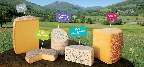
Of course, as every French region, Auvergne is very well-known for its regional products. But it is also home to some of France’s best companies like Michelin, whose headquarters are located in Clermont-Ferrand – and, which, incidentally, gave birth to one of the most revered and dreaded Food Guide on the planet (there is some kind of repetition going on here, don’t you think? It sure seems like in France, all roads lead to food)! Auvergne is one of France’s major cheese regions, and even has its own "Road of Cheeses"! Follow it and you will discover the five "star" cheeses of the region: Saint-Nectaire, Fourme d’Ambert, Bleu d’Auvergne (Blue Cheese of Auvergne), Salers and Cantal.
Of course, lots of products have made Auvergne famous, like the Puy Lentils, Salers’ cows, Chanturgue (Red wine), Gentiane (liqueur) and Verveine du Veley-Pagès (liqueur).
Spotlight of Auvergne
Natural wealth of Auvergne
Salers, one of the most beautiful village of France
French Corner is our monthly rendez-vous where we showcase a French region and introduce you to its highlights and secrets, appeal to your palate and culinary talents with our local recipe of the month and fspotlight France’s scientific and educational competitiveness with school and universities of the region! We use also this opportunity to interview one of our expats’ of New England